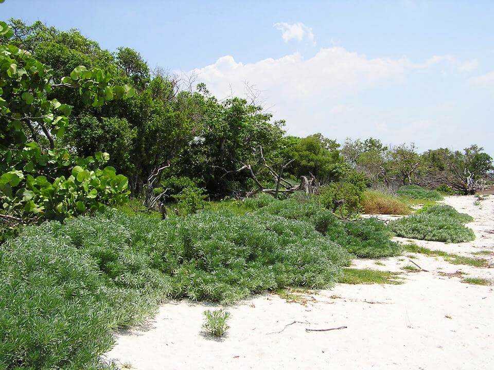
- Coastal Berm
Coastal Berm
within Coastal Uplands
Vulnerability:
General Information
Coastal berms develop on ridges of storm deposited sand, shells and debris. They form parallel to the shore, occasionally occurring in a series with alternating swales. Vegetation is variable with dense thickets of large shrubs and small trees, hammocks, or sparse shrubby vegetation with spiny xerophytic plants. Typical plants include cabbage palm, cocoplum, sea grape, marsh elder, greenbrier, prickly pear cactus, evening primrose, Spanish bayonet, wax myrtle, lie oak, muhly grass, sea oats, sea oxeye, coral bean, strangler fig and wild coffee.
Area
- 425 hectares within Florida (modeled)
- 368 hectares (86%) is located on public lands
Area impacted by up to 3 meters sea level rise:
Climate Impacts
Coastal berm habitat is likely to have 98% of the current area inundated by 1 m of sea level rise and 100% inundated by 3 m of sea level rise. Inundation and impacts from storm events will lead to increased fragmentation and changes in the structure (geomorphology) of the system. Increased soil salinity will lead to changes in species composition as salt intolerant plants decline and plants with higher salt tolerances increase.
Increased temperatures, as well as extreme events will enhance invasive species processes, from introduction through establishment and expansion.
More information about general climate impacts to habitats in Florida.
Climate Impacts to Species
Beach mice will be impacted by habitat degradation as dune plant species composition changes (potential loss of food plants), habitat fragmentation as dunes become more disjunct from one another due to inundation, and habitat loss from inundation.
More information about general climate impacts to species in Florida.
Other Non-climate Threats
- Coastal development
- Conversion to housing and urban development
- Conversion to recreation areas
- Incompatible recreational activities
- Industrial spills
- Invasive animals
- Invasive plants
- Roads, bridges and causeways
- Shoreline hardening
More information about climate change interactions with existing threats and stressors in Florida.
Vulnerability Assessment Details
This habitat was assessed as part of the Standardized Index of Vulnerability and Value Assessment - Natural Communities (SIVVA).
This habitat is within the top 5 most vulnerable natural communities in one but not all of the SIVVA vulnerability categories.
Read more information about SIVVA natural communities.
Adaptation Strategies
Protection
- Protect potential refugia, corridors, and relocation sites.
- Protect coastal vegetation to reduce the impact of increased disturbance events (intense storms, increased erosion) and encourage aeolian sand capture.
- Create setbacks or rolling easements.
- Preserve undeveloped and vulnerable shoreline.
- Identify and protect locations where native species may shift or lose habitat due to climate change impacts.
- Develop conservation easements to protect climate-vulnerable areas.
- Maintain corridors and linkages between undeveloped areas.
Restoration
- Restore and/or protect coastal vegetation to reduce the impact of increased disturbance events (intense storms, increased erosion) and encourage aeolian sand capture
- Develop corridors and linkages between undeveloped areas.
- Reduce impacts from points of access (e.g., paths, boardwalks).
- Remove invasive plants and prevent new species from becoming established.
- Restore native plant communities, using stock that is more likely to persist in future climatic conditions.
- Redesign or mitigate existing physical barriers or structures that impede movement and dispersal within and among habitats.
- Restore coastal vegetation to improve habitat for species that require early successional habitat.
Planning
- Coordinate with County staff to incorporate sea level rise adaptation strategies into comprehensive plans and post-storm redevelopment activities
- Identify areas particularly vulnerable to loss or transition under climate change and develop management strategies and approaches for adaptation.
- Modify conservation management priorities to include species and habitat adaptation to the effects of climate change.
- Incorporate altered or restricted points of access into plans to accommodate impacts from climate change.
Policy
- Consider restrictions on other human activities (e.g., mechanical beach cleaning, armoring) that pose a threat to species through disturbance and/or habitat degradation
- Restrict development and other land uses that alter disturbance processes in sensitive areas
- Centralize recreation impacts to easy-access areas.
- Identify overused areas and limit recreational trails/roads and OHV use.
- Zone development away from sensitive and hazard-prone areas.
- Provide greater regulation and enforcement of recreational use and access restrictions.
- Institute or strengthen building codes in flood- and erosion-prone areas to reduce erosion.
Education and Outreach
- Educate landowners and planners on benefits of structural walkways over vegetation rather than pedestrian pathways through vegetation/dunes.
- Educate planners on the importance of healthy resilient coastal systems to protect against coastal hazards.
- Work with communities and landowners to choose vegetation, living shorelines, oyster reef restoration, or hybrid approaches in favor of traditional hard armoring.
- Work with communities and landowners to choose native vegetation in favor of non-native vegetation.
- Promote “keeping cats indoors” to protect beach nesting activities .
